Sunday, August 29, 2010

Scenes of Wisconsin, Summer of 2010

I always keep my cameras close and over the course of the last months (and years) have assembled quite the collection of footage that I don’t use.  When I first started doing video I often created what I call “Art” videos.  I was surprised that often these are some of my most popular and most often viewed videos.

As I have been focused on featuring to much of what I am planning to do in my future video, and not enough time and content actually creating the content, I thought this would be a nice change of pace.  In a way almost “regressing”. 

The economy and amount of video work I am getting these days also has effecting my operating budget.  The cost of going out and covering events and stories with no compensation has become difficult to cover, so I have been staying more “local”, or close to home.

Here in this video I have created a sort of “collage” or as I call it in the video a “Clip/slideshow”.  There is not story here or any message being conveyed, so I hope everyone enjoys the pretty pictures and shots.

Thanks for checking out my blog and viewing my videos.
Friday, August 20, 2010

Heavy Rain and Hail Strike Northeast Wisconsin, Bellevue and Green Bay WI

Heavy rain and up to quarter size hail fell in North East Wisconsin this afternoon starting at around3pm this  afternoon. Street flooding was reported in Green Bay, including at the location of WFRV TV on Mason and Rosevelt streets in Green Bay.  

According to the most recent
bullitin from the
National Weather Service more is expected for this evening.

One can look at one of the recent postings below for a view of the current radar.

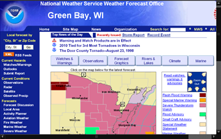
Here is the most recent warnings.

BROWN WI-KEWAUNEE WI-OUTAGAMIE

WI-MANITOWOC WI-WINNEBAGO WI-CALUMET WI-635 PM CDT FRI UG 20 2010.A SEVERE THUNDERSTORM WARNING REMAINS IN EFFECT FOR NORTHERN CALUMET.NORTHERN WINNEBAGO.NORTHERN MANITOWOC.OUTAGAMIE. image

KEWAUNEE & BROWN COUNTIES UNTIL 700 PM CDT. AT 630 PM CDT.NATL WEATHER SVC DOPPLER RADAR INDICA TED A LINE OF SEVERE THUNDERSTORMS CAPABLE OF PRODUCING DAMAGING WINDS IN EXCESS OF 60 MPH. THESE STORMS WERE LOCATED ALONG A LINE EXTENDING FROM BLACK CREEK TO GREEN BAY TO KEWAUNEE.MOVING NE AT 60 MPH. THE STRONG WIND GUSTS MAY LAST FOR UP TO 30 MINUTES.